
Accountability need of the hour to check ecological destruction in Himalayas
Accountability need of the hour to check ecological destruction in Himalayas
S.M.A. KAZMI
Dehradun, Aug 6
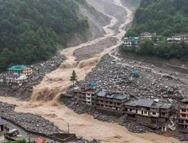
The magnitude of death and destruction caused by massive flood following cloud burst or leakage of glacial lakes in Kheer ganga a tributary of Bhagirathi river at Dharali village in Uttarkashi district of Uttarakhand has again pointed towards the fragility of mid Himalayan region to natural disasters which are frequently taking place but also indicate alarming rise in Human interference in fragile mountain eco-system.
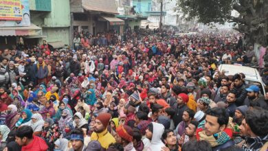
Five persons have been confirmed dead and more than seventy persons feared missing in the disaster as the world watched the video of the destruction of the village caused by massive flood which destroyed homes, hotels and home stays in the village which acted as a tourist and religious pilgrimage centre on way to revered Hindi shrine of Gangotri. Ten army personnel are also reportedly missing as massive relief efforts together by Indian army, National Disaster Relief Force (NDRF), State Disaster Relief Force (SDRF) and Uttarakhand police along with civil administration is underway. Uttarakhand Chief Minister Pushkar Singh Dhami visited Uttarkashi to oversee the relief works.
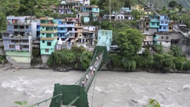
Another striking image of video showing the destruction caused by the massive flood was destruction of the high rise- four or five storied building. Such high rise hotels were also seen titling at Joshimath due to land subsidence as thousands were relocated from their hearths and homes. Throughout Uttarakhand, a seismically active zone, high rise buildings in the hills is a common sight with large scale construction and urbanization taking place. Most of the villages in the hills have turned into mini townships and towns expanded without any planning. These developments are grim reminder of the increasing pressure of developmental needs of the people and the fragility of the Himalayan mountains.
But the question arises, who gave the permission for such construction? Do the state government has any concrete policy for urban planning/ There is urgent need for accountable of people giving such permissions for economic gains.
The Himalayas are the youngest, tallest and the most fragile mountain ranges in the world which are still in the making. However, the pace of rapid urban development and construction of roads, hydro-electric projects and railway network has disturbed the fragility of the Himalayas.
Landslides, earthquakes, avalanches and floods are frequently taking places in the Himalayan region. To compound the problem, there is a marked lack of proper scientific studies on the impact of all these activities. Interestingly, the recommendations of expert committees formed after such natural disasters or Supreme Court ordered do not find favour with the centre and the state governments.
After the Kedarnath tragedy in which more than 5000 people perished in 2013, an expert committee headed by eminent scientist Dr Ravi Chopra recommended that all the Hydro-electric project above 2000 meters should be halted citing increasing threats of landslides, cloudburst and flash floods. The committee also recommended detailed study of impact of the hydro-electric project in terms of deforestation/tunneling/blasting reservoir formation of hydrology of the area but nothing was done. The Supreme Court also halted permission to 23 hydro-electric projects in the state.
Interestingly, the people of Reini village, the epi-centre of the 1970 Chipko movement where Rishiganga power project was the first to be hit by the flash flood in February 2021 in Chamolidsistrict , had moved the Nainital high court in 2018 against dangers to the eco-system of the area caused by the blasting being carried out by the project authorities. The state government instead of acting firmly tried to push the issue under the carpet.
Even before the Kedarnath tragedy in 2013, eminent environmentalist Prof G.D. Aggarwal alias Swami Sanad who had been fighting against bigger hydro-electric projects in Himalayas particularly on river Ganga since 2008 had to sacrifice his life while undertaking fast unto death in support of his demand. He had forced the state government in 2008 to abandon Pala Maneri and Bhaironghati hydro-electric project. He again started his fast in June 2018 in support of his demand of uninterrupted flow of river Ganga and died in October 2018.
The problem of landslides and cloudbursts normally occur in the monsoon period but the weather data of Uttarkashi during the past few days showed that there were not much rains. Scientists believe that it could be due to leakage of glacial lake upstream of Kheer Ganga tributary above Dharali town. There is need to understand the scientific phenomenon behind such occurrences.
Geologists say that seismic movements are constantly taking place in the Himalayas. On an average, nearly 200 earthquakes of smaller magnitudes occur every year in the Uttaranchal region alone. Most of these are undetected by local communities.
The seismic activities lead to landslides. Thousands of landslides of medium to large dimensions have been occurring in the Himalayas every year. But they become noticeable only when accompanied by death of human beings and destruction of property.
A major part of the Himalayas, particularly in Uttarakhand, usually receive heavy monsoon showers and also some rain in the winter months. However, like in 2013 Kedarnath tragedy, the combined precipitation of a a western disturbance from Arbian sea and Monsoon rain from Bay and Bengal compounded the rain fury in North India.
The uncontrolled, downhill flow of water after heavy rains, particularly along barren slopes, remain one of the major causative factor of landslides.
Apart from geological factors, changes in the land-use pattern in the mountains has also led to the increase in the frequency and magnitude of landslides. Most of the roads are carved out on the banks of the river valleys and towns are situated on these roads. Every monsoon during floods most of these roads are washed away disrupting the road communications.
The most obvious of these changes has been the rapid destruction of forests which has left large tracts in the entire Himalayas region with denuded slopes.
The destruction of forests and the vegetative cover that binds the top soil has been going on at an ever-increasing pace because of various developmental activities in the region, including the expansion of the road network, construction of a large number of hydro-electric projects, underground tunnels, the establishment of new townships and the expansion of the existing ones and the conversion of forest land into agricultural and horticulture holdings.
The use of explosives to blast surfaces of the mountains while making roads has wrought its own brand of havoc. Similarly, 30,000 to 40,000 cubic meters of soil is excavated in carving out 1 km of road in the Himalayas – a figure that eloquently reveals the extent of damage done to the local ecology.
To make matters worse, most roads are built without proper surveys. These invariably cause new landslides or reactivate old ones.
Sadly, no holistic approach is being evolved for developmental process in the hills to measure the geological fallout of the developmental and construction activities despite the fact that each hill district has a government geologist to advise the administration.
The recent tragedy has also started a debate about the health of glaciers in the state. The report of an expert committee which gave recommendations on ways and means to safeguard the glaciers in 2006 has been gathering dust in the state secretariat.
Unbridled urbanisation has also done its bit in making the region more unstable. Changes in the architecture of the houses in the hills – the increasing use of brick and concrete instead of the traditional mud and wood – has resulted in higher casualty figures when disasters strike.
The country needs a separate institution dealing with mountain hazards in general and landslides in particular. Despite hue and cry raised by the scientific community, the proposed centre for landslides study and control is yet to come up.
The National Disaster Management Authority has claimed that the Ministry of Mines will set up a Centre for Landslides Research, Studies and Management in a landslide-prone state to deal with the problem in a comprehensive manner.
A proper geological and geo-technical survey is vital before launching any developmental project in the hills, including the preparation of landslide-hazard zonation maps, so that prior knowledge about the status of the area to be undertaken for development is available.
True, landslides can also occur anywhere at any time, but unlike earthquakes, their occurrence can be predicted and planned for.
The tragedy is that despite a wealth of data and numerous experts in the field, there is very little planning going on.
The tragedy is that it is the construction lobbyists and the mafias dealing in Himalayan timber and stone, working in league with politicians and administrators, who finally get to set the agenda for the development of the region.
The people of the Himalayas continue to die as their land slips from under them and their houses collapse over them. There has been an urgent need to change this all.(ends)